Cyclone Alfred has hit Queensland’s outer islands and is forecast to cross the mainland between Maroochydore and Bribie Island before 12pm (local time).
The tropical cyclone – the first to hit south-east Queensland and northern NSW in half a century – has been downgraded to a category one system.
It is forecast to weaken below tropical cyclone strength as it makes landfall.
It is still predicted to bring gusts of up to 95km/h, heavy rain and life threatening floods.
A man was swept away in floodwaters in northern NSW on Friday afternoon and remains missing.
Follow Daily Mail Australia’s live coverage of the cyclone’s movements.
Cyclone Alfred hits Queensland’s outer islands
Tropical Cyclone Alfred has been downgraded to a category one system as it hits Queensland’s outer islands.
As of 4am, the cyclone was close to Bribie Island and moving 10km/h to the mainland with 65km/h winds near the centre and gusts of up to 95km/h.
It was 55km northeast of Brisbane and 55km southeast of Maroochydore, and is expected to make landfall in the next few hours.
As Alfred crosses the coast, it is forecast to weaken below tropical cyclone strength.
Despite its weakening, heavy rainfall, wind and high swells are likely to continue over southeast Queensland and northeast NSW during the weekend.
The warning zone has been reduced from 650km to 160km, and now stretches from Noosa to Brisbane, but doesn’t include the Queensland capital.
More than 200,000 homes now without power as Alfred continues to batter southeast Queensland – as it’s scheduled to make landfall at 8am
There are more than 200,000 homes without power in Queensland with Cyclone Alfred just hours away from making landfall.
The Gold Coast is especially being hammered by cyclonic winds and torrential rain from the catastrophic weather event, with more than 118,00 of its homes plunged into darkness.
Gold Coast residents were warned to bunker down for up to 36 hours from Friday afternoon as they felt the terrifying conditions worsen.
Local Disaster Coordinator Mark Ryan said it was possible people would have to ‘shelter in place’ for 24 to 36 hours from 4pm Friday.
As of 2am on Saturday, Energex has reported more than 200,000 power outages across the state.
Redland City was the next worst region impacted by the weather event and it recorded close to 40,000 homes without power.

Alfred is forecast to make landfall near Redcliffe as a category 1 cyclone by 8am local time on Saturday, before continuing through Moreton Bay and progressing towards Dalby.
An update from the BOM at 1am had the cyclone just 20km away from the Moreton Bay islands, 55km northeast of Brisbane and about 75km northeast of the Gold Coast.
Wind gusts have been recorded at up to 120km/hour while the bureau has also warned of significant rain and flooding.
‘Heavy to locally intense rainfall which may lead to dangerous and life-threatening flash flooding is likely to develop overnight and increase into Saturday,’ an update read.
‘Once Alfred crosses the coast, it is likely to weaken below tropical cyclone strength later on Saturday.
‘However, heavy to locally intense rainfall is expected to continue near and south of the system centre during the weekend.’
An emergency alert for dangerous flash flooding was issued for Currumbin Valley with residents told it was too late to leave and they have to get to higher ground.
Those living in the Gold Coast, Redland City, Moreton Bay and Brisbane have all been told to seek shelter immediately with millions thrown into a cyclone lockdown.

Council warns Brisbane residents to move to a secure part of their house and expect to hear ‘things breaking outside’
Brisbane City Council has ordered residents to take shelter immediately as Cyclone Alfred was predicted to cross north of the city overnight.
The council advised residents to go to the strongest, safest part of the building and remain there while staying away from big windows.
It could be a bathroom, walk-in wardrobe, or hallway.
Cyclonic winds and tidal surges caused destruction across southeast Queensland ahead of Alfred’s landfall.
‘The wind is very dangerous and will be very loud,’ the statement said.
‘You will hear things breaking outside and hitting your house.
‘Winds could stop suddenly if the eye of the tropical cyclone goes over. Very dangerous winds could start again quickly from a different direction.’
Residents scramble for last-minute supplies as Cyclone Alfred creeps closer
More than 100,000 homes without power now with the Gold Coast by far the worst hit
As of 9.45pm more than 100,000 homes in southeast Queensland were without power as Cyclone Alfred closed in.
Energex reported 100,622 homes were affected which was nearly 40,000 more than reported just over two hours earlier.
Residents on the Gold Coast are most affected with 86,000 homes without power as opposed to just 1,078 in Brisbane City.
Redland City in the second worse hit spot with 10,075 homes left in the dark.
The latest tracking map from the Bureau of Meteorology shows Tropical Cyclone Alfred reaching the mainland at 8am, Queensland time, where it should be downgraded to a category 1 system.
New modelling has Alfred arriving earlier than thought
The Bureau of Meteorology has released its latest data, showing Cyclone Alfred will be arriving earlier than it was reported just an hour ago.
It’s now expected to make landfall at 7am Queensland time in Brisbane.
Alfred is sitting 95km east of Brisbane, and 75km northeast of the Gold Coast.
Predictions have been changing regularly but Alfred is still a category 2 cyclone at the moment and may be downgraded by the time it makes landfall tomorrow.
Even if it is downgraded to a category 1, it won’t affect the amount of rain that falls as the ratings system only accounts for wind speeds.
Election not a priority for Albanese who says sole focus is on Cyclone Alfred
Anthony Albanese will not call an election this weekend as his government dedicates all its resources towards dealing with Cyclone Alfred.
The Prime Minister confirmed the news during an interview on 7:30 where he categorically ruled out the option.
He told host Sarah Ferguson that he would not be calling the election on Saturday or Sunday while the government works to focus on the incoming cyclone.
Mr Albanese was initially set to call the election directly after the West Australian state election over the weekend for April 12.
Now he has confirmed it will not be called until at least after Monday next week.
‘I have no intention of doing anything that distracts from what we need to do,’ the Prime Minister said.
‘This is not a time for looking at politics.
‘My sole focus is not calling an election, my sole focus is on the needs of Australians, that is my sole focus.’
At least 60,000 homes now without power in Queensland as the Gold Coast is worst hit
Roughly 60,000 homes are without power in southeast Queensland, as Cyclone Alfred takes hold, and the number is expected to rise throughout the night.
Premier David Crisafulli told the ABC’s 7.30 more and more powerlines have come down across the region.
‘We’ve just gone past 60,000 … only in the recent moments, so that gives you a degree of how large that scale is,’ he said.
‘Most of those are on the Gold Coast, but there’s also a number of the Bay Islands and in the Redlands area.’
The Premier said there weren’t enough generators to bring power back to many in the worst hit areas
‘The real work is actually reconnecting so you can get permanent power supply,’ Mr Crisafulli said.
Telstra and NBN outages now widespread across NSW and QLD as Alfred takes hold
Telstra and NBN services are now experiencing widespread outages to their New South Wales and Queensland networks after landlines were damaged.
Telstra regional general manager Michael Marom said the outages were due to Cyclone Alfred as it nears closer to the east coast.
‘Power outages due to Tropical Cyclone Alfred are affecting some mobile and landline services, mainly in parts of the Gold Coast’s south and northern NSW,’ he said.
‘Our network sites have backup systems that are keeping many services running for as long as possible, but customers should be prepared for disruptions if power’s out for a long time in their area, or if access is cut to a site.’
More than 40 mobile sites have been disrupted across both states, as were 2769 landline phone services, while 1083 ADSL services are affected.
Telstra said it was working to fix the outages and would offer assistance packages to those affected.
The NBN network has also suffered 30,000 impacted services.
Gold Coast residents among those told now is time to take cover as Cyclone Alfred gets ready to hit
Redlands, Moreton Island and Gold Coast residents have been told to take shelter now and steer clear of big windows.
‘It could be a bathroom, walk-in wardrobe, or hallway,’ the emergency warnings read.
Gold Coast and Redland City councils issued the alerts at 4pm AEST, while Brisbane City Council issued the Moreton Island alert at 5pm AEST.
Gold Coast City Council said: ‘If you experience flooding, get up as high as you can where you are. This could be a kitchen bench or second story.’
Destructive wind gusts of up to 155km/h are expected to develop tonight and last through to early Saturday morning.
Tips for residents in the cyclone’s path include:
- Cover any windows in your safe room with a mattress or heavy blankets. This could protect you if the window breaks. Keep all doors and windows closed.
- If the roof comes off, shelter under your mattress and blankets.
- Stay in your safe place. This could be for several hours.
- Watch for more flooding around you after the winds ease.
- Keep pets in a safe place inside.
- Do not use generators inside. Fumes can be deadly.
- Limit use of devices to save batteries. Listen to local radio for updates.
Kiwis lend a hand to help Aussies fighting Alfred
Australia’s neighbour New Zealand has come to help the fight against Cyclone Alfred and will send over 66 defence personnel.
They are currently on their way over as Alfred looms off the southeast Queensland and northern NSW coasts.
Prime Minister Anthony Albanese talked to Prime Minister Christopher Luxon and the New Zealand leader responded.
‘Our friends across the ditch in New Zealand, I thank Prime Minister Luxon for this,’ Mr Albanese said.
‘We have been in touch with each other. There are 66 personnel on their way from New Zealand as well, which is really appreciated.
‘It’s just an example of what we’re seeing at this difficult time which is not just Australians helping out Australians, but around the world as well, people being very conscious of this difficult time and being prepared to help.’
Man missing after being washed away in floodwaters in northern NSW
A man was washed into floodwaters this afternoon in northern New South Wales and is still missing.
At about 2.20pm emergency services responded to reports that a 4WD had been washed off the Wild Cattle Creek Bridge, 23km northeast of Dorrigo, into fast running water.
The driver was able to get out of the vehicle and grab on to a tree branch about 30m from the river bank.
Police were talking with the man but shortly after 3pm he was swept from the tree and disappeared under the water and has not been seen since.
Police and the SES are looking for the man and are waiting for a helicopter to join the search.
No further information is available at this stage and anyone with any information about the incident should call Crime Stoppers on 1800 333 000.
Terrifying moment power lines spark in gale
A woman has shared frightening footage of sparks flying from damaged power lines at Tweeds Head West on Thursday evening.
The Bureau of Meteorology has warned that Cyclone Alfred is creating ‘damaging wind gusts’ up to 120km/h between Cape Moreton and Cape Byron, and the speed will pick up as the storm moves closer to Queensland’s coast.
Thousands to be left in darkness for over a WEEK
Tens of thousands of homes could remain without power for a week after Energex crews were forced to abandon crucial repairs due to dangerous weather conditions.
More than 46,000 households across southeast Queensland have been affected by the outages, with the majority on the Gold Coast, as of 4.30pm on Friday.
Redland City and the Scenic Rim have also been heavily impacted.
‘If we get hit hard, some areas may be without power for more than a week, so people must be prepared at home to be without power for at least a week,’ Energex spokesman Danny Donald said.
‘The strong winds have carried debris, tree branches, whole trees, everything onto the network,’ he told The Courier Mail.
‘We’ve had some debris that has taken out the substation at Tugun.’


Wild weather destroys home
Two people living in the Gold Coast hinterland narrowly escaped tragedy after gales from Cyclone Alfred caused a huge gum tree to fall on their home.
The Queensland Ambulance Service shared terrifying images of the destroyed house located in Currumbin Valley.
The pair sustained minor injuries and were transported in a stable condition to the Gold Coast University Hospital.


Batten down the hatches: Those in the front line told it’s now too late to leave
Tropical Cyclone Alfred is 110km off the mainland and conditions are rapidly intensifying as the coast is lashed by ‘damaging wind dusts’ of 120km/h.
It is now too late for those in the frontline of the category two storm’s collision course with the coast to flee, and they should now go to ground and ride it out, the Bureau of Meteorology warns.
The cyclone – the worst to hit southeast Queensland and northern NSW in more than half a century – is currently 145km southeast of Brisbane and 110km off the Gold Coast.
‘People between Cape Moreton and Yamba, including the Moreton Bay Islands should remain inside until conditions have eased,’ the Bureau says.
‘People between Yamba and Grafton in NSW, as well as Brisbane and Double Island Point in Queensland should take precautions.’
The Bureau warns the raging system has ‘sustained winds’ of 100km/h near its centre with gusts in excess of 140km/h and is continuing to slowly power towards the mainland at 7km/h.
‘Alfred is most likely to cross over the Moreton Bay Islands Saturday morning before crossing the mainland coast, most likely between Noosa and Beenleigh later during Saturday,’ the Bureau says.
‘Heavy rainfall bands are continuing to extend over southeast Queensland and northeast NSW.
‘Dangerous and life-threatening flash flooding is likely to develop from this afternoon.
‘Once Alfred crosses the coast, it is likely to weaken below tropical cyclone strength later on Saturday.
‘However, intense rainfall is expected to continue near and south of the system centre during the weekend.’
The Bureau warns the coast will continue to be battered by ‘abnormally high tides’ while ‘damaging surf’ conditions could cause ‘significant beach erosion’ thoughout the storm.
‘Gales with damaging wind gust to 120km/h are expected to extend along the remaining southeast Queensland and northeastern NSW coastal and island communities between Noosa and Yamba later today as Alfred approaches the coast,’ the Bureau says.
‘These winds may extend as far south as Grafton and northwards to Double Island Point in the evening or Saturday morning.’
The BoM predicts the wild weather will continue to intensify in the coming hours with the Gold Coast to experience to full force of Alfred’s wrath come Saturday morning.
‘Destructive wind gusts of up to 155km/h may develop about the Moreton Bay Islands and exposed coastal locations on the northern Gold Coast from tonight as Alfred’s destructive core approaches the coast,’ the Bureau says.
‘The destructive winds may persist until Alfred crosses the coast early Saturday morning.
‘Although Alfred is expected to weaken and move inland during Saturday, damaging wind gusts may continue, particularly over elevated terrain during Saturday, before easing throughout during Sunday.’
Scammers already looking to cash in on carnage caused by devastating storm
Unscrupulous scammers are trying to cash in on the devastation Cyclone Alfred is expected to cause to homes and businesses along the coast.
Although the majority of the community has been rallying together ahead of the looming storm, Lismore MP Janelle Saffin says there have already been reports of fake fundraisers online.
‘Unfortunately, the scams have started,’ she said on Friday.
‘A scam started this morning, and I say to people, if you see somebody’s name on it that’s not well known, just ignore it.’
Ms Saffin hopes people will continue to offer much-needed aid and support in the weeks ahead by sticking to trusted sources.
Her comments come after the Northern Rivers town she has called home for the past 45 years was evacuated on Thursday night amid warnings it would be hit with severe flash floods even before Cyclone Alfred makes landfall.
The majority of Lismore’s 40,000 residents were urged to leave before 9pm on Thursday with fears floodwaters would see the Wilsons River break its banks and cut off evacuation routes.
The SES warned those who refused to flee risked being trapped in the town as it would be too dangerous to attempt to rescue them and that power, water and other key services were likely to be cut.
The Wilsons River has already burst its banks at key spots with moderate to heavy rainfall recorded in excess of 250mm throughout the catchment area since Wednesday.
Rapidly rising water levels are expected to continue throughout the night with the Bureau of Meteorology predicting major flooding throughout Lismore from Saturday morning as the storm conditions intensify.
The Bureau says the Wilsons River at Lismore is currently at more than 5.1m and rising – exceeding the ‘minor’ flood level of 4.2m.
The river is expected to rise by another 2m throughout the day and exceed the ‘moderate’ flood level of 7.2m by Friday evening.
It is predicted to grow by yet another 2.5m on Saturday breaching the official ‘major’ flood level.
The wild weather comes less than two years after the regional city was devastated by 14.4m floods in 2022 with many residents still struggling to rebuild.


Chickens all cooped up indoors ahead of storm
Moreton Bay local Ally Karin has come up with an ingenious way of keeping her prized chooks Barb and Joscelyn safe from the wild wet weather outdoors… by converting her own shower indoors.
Ms Karin, who hails from D’aguilar near Woodford, shared photos on Facebook of her new makeshift coop.
‘It just seemed the safest spot for them, nice and enclosed,’ she told the ABC.
‘They say the safest place in your house is the smallest room, usually the bathroom.
‘It will be easy to clean up too (thanks to) the bendy showerhead hose thing.
‘They’re happy enough, it’ll keep them dry.’

Moment of magic in the midst of cyclone chaos
One proud mother has experienced a ‘moment of magic’ amid the chaos and impending carnage of Tropical Cyclone Alfred.
Queensland Premier David Crisafulli says a local mum in Dunwich, on North Stradbroke Island, gave birth to healthy twins overnight as the region was rapidly going into lockdown mode.
‘We had paramedics and midwives who assisted the mum and they continue to care for her,’ he says.
‘That’s one of those little gems in an otherwise really stressful time for everybody.’
Gold Coast residents to bear the full brunt of Alfred’s wrath
Gold Coast residents will experience Cyclone Alfred’s full fury when it finally makes landfall midmorning on Saturday.
The Bureau of Meteorology says the densely populated coastal city will be struck by raging winds of up to 150km/h as the category 2 system wreaks havoc along the coast.
But by the time the storm works its way inland to Brisbane, it is forecast to have weakened to a category 1 storm.
This means that while the Queensland capital will still be slammed by gusts of up to 120km/h, it could be spared the worst of Alfred’s wrath.
Both cities are in for a deluge, though, with the Bureau’s Matthew Collopy saying intense rainfall is forecast across the state’s south-east, with daily totals of between 300mm to 500mm.
‘As the cyclone moves across Moreton Bay islands, it is expected to weaken from a category two to a category one system,’ he says.
‘This will mean that destructive winds are unlikely for Brisbane itself.
‘But damaging wind gusts to 120km/h are expected, and they will develop quickly as the system approaches.
‘We may (also) see 800mm totals for this event as it stretches through the next 48 hours or so.’
Coles and Woolworths close their doors as storms set in
Coles and Woolworths supermarkets are closing across southeast Queensland and northern NSW as wild storms intensify.
Queensland premier David Crisafulli says the government has been working with the supermarket giants to ensure they could ‘stay open as long as possible’ but that outlets are beginning to close ‘on a case by case basis’ in affected regions.
Coles shut its stores on the Gold Coast on Friday morning as well as at eight key locations across northern NSW, including Tweed City, Lismore, Ballina and Murwillumbah.
More stores are scheduled to shut throughout the afternoon, with Coles’ Brisbane supermarkets all set to close between 2pm and 4pm and its Sunshine Coast and Grafton outlets at 4pm.
‘As Cyclone Alfred gets closer, we have made the decision to begin closing our stores in highly impacted areas,’ a Coles spokesperson says.
‘This will ensure our team have time to get home while it is still safe.
‘We will keep a close eye on the impacts from Cyclone Alfred, and make a decision on reopening our stores as soon as it is safe to do so.’
The chains have done their best to keep shelves stocked with essentials in the lead up to the cyclone despite widespread panic buying that has sent residents driving hours inland to snap up supplies.
Premier Crisafulli says 1,049 schools have also been shut, along with 2,081 childcare centres, while all public transport from Noosa to northern NSW will be suspended from tomorrow.
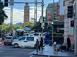
Eerie scenes as millions of residents desert city streets and go into lockdown
Brisbane has turned into an eerie ghost town as millions of residents retreat into their homes as they wait for Tropical Cyclone Alfred to unleash its full fury on the city.
After almost a week of nervous anticipation, the category 2 system has again been delayed and it now expected to cross over the Moreton Bay Islands about 7am on Saturday before hitting the mainland between Noosa and Beenleigh about three hours later.
The state’s southeast is already experiencing gale force winds in excess 100km/h and enduring heavy downfalls as the storm thunders towards the coast at a speed of 8km/h.
The belated arrival means that the region is now expected to be battered by storms for up to five days instead of three, with wind gusts of up to 155km/h and a deluge of 800mm rain predicted over the weekend.
More than 84,000 homes and businesses are already without power across the Gold Coast and northern NSW amid warnings the blackouts will go on for days because it is simply too dangerous to send out repair crews during the dangerous weather conditions.
Even more are expected to lose access to electricity in the coming 24 hours as wind speeds continue to increase and more powerlines come down.
A major electricity substation at Tugun on the Gold Coast has already been taken out by wind-blown debris, adding to the widespread outrages.
Prime Minister Anthony Albanese says authorities are ‘hoping for the best but preparing for the worst’.
He has dispatched more than 100 Australian Defence Force personnel to reinforce the regions’ hard-pressed SES volunteers.
He warns residents should not be deceived by the slow progress of the storm – which simply means the region will be battered by wild weather for even longer.
‘As it is over warmer waters (it also has) the potential to increase intensity,’ he says.
The only positive is that the steady pace has given locals a little more time to prepare for the onslaught before going into lockdown.
Traffic cameras throughout Queensland’s southeast reveal the region is now virtually empty with even its busiest streets devoid of any cars.
It comes as the eye of the storm is now clearly visible on the Bureau of Meteorology’s Brisbane radar loop, and the agency has begun to issue rolling, hourly updates on the cyclone’s progress.


Prepare for days without power – it’s too dangerous for crews to undertake repairs
NSW Minister for Housing Rose Jackson warns local residents will likely remain without power for days due to the danger of conducting repairs during a cyclone.
She says some 35,000 homes and businesses in northern NSW remain without electricity and warns there will be more power outage in the days ahead.
‘The extent of the winds and the damaging winds we are going to see, it is fair to say people who have power be prepared it may go out,’ she says.
‘People need to have clear expectations that power is likely to be out for a few days and the number of people who are without power is likely to grow.
‘If you currently have power in this region we really encourage you to make sure your phone is charged, devices are charged, make sure there are batteries in your torch.’
Early call made to keep hundreds of schools closed on Monday
NSW deputy premier Prue Car says hundreds of schools will be closed next week as the state’s north is smashed by storms.
She says 343 schools and 17 TAFEs will remain closed until at least Monday and that the lockdown could continue into the following week.
Northern NSW has already been inundated with flash floods and coastal tidal surges as Cyclone Alfred slowly thunders towards the coast.
‘With the event of this tropical cyclone coming over the weekend, and then the impact after that, the schools that are currently closed will remain non-operational on Monday,” she says.
‘As soon as we know what we’re doing on Tuesday the schools will be informed and will inform the community because my biggest priority is keeping the students and staff of those schools safe.’
Albanese: ‘Climate change is having an impact on our weather patterns’
The Prime Minister says he believes climate change has played an obvious part in the impending natural disaster about to hit southeast Queensland and northern NSW.
‘What we know is that the science tells us that there would be more extreme weather events, they would be more frequent and they would be more intense,’ he said in a press conference on Friday morning.
‘I think anyone who looks at the science knows that is what is occurring.’
His comments come as Cyclone Alfred becomes the first category 2 system to ravage the region in more than a century when it makes landfall on Saturday.
‘You can’t say this is just because of climate change,’ Mr Albanese said.
‘(But) what you can say is that climate change is having an impact on our weather patterns.
‘The world’s hottest years have been increasing from year to year.’
Prime Minister Anthony Albanese: I’m hoping for the best but preparing for the worst
Prime Minister Anthony Albanese says authorities are ‘hoping for the best but preparing for the worst’ as he dispatches more than 100 Australian Defence Force personnel to southeast Queensland and northern NSW.
Speaking from the National Situation Room in Canberra this morning, Mr Albanese revealed he has approved the request as Cyclone Alfred continues on its slow-moving collision course with the country’s east coast.
The category two system has been delayed yet again and is now forecast to hit the mainland as late as 10am on Saturday, according to the Bureau of Meteorology’s latest tracking data.
Mr Albanese says while the system has slowed, ‘we should not think that slower means better’.
‘As it is over warmer waters (it has) the potential to increase intensity,’ he says.
‘I have approved the request for 120 ADF personnel to depart immediately for NSW, they’ll work today supporting the local SES door knocking as well as conducting welfare checks on vulnerable members of the community.
‘They will also support the SES with road clearance, sandbagging, clearing access to critical infrastructure, damage assessments and essential services.’
He says Australia’s Chief Medical Officer has also activated the Department of Health and Aged Care’s national incident centre to co-ordinate the state and federal response to the looming natural disaster.

Huge fines for those who break this cyclone rule
Aussies could be slapped with a $16,000 fine for ‘reckless actions’ on rock walls, piers, and beaches as conditions worsen on the east coast.
The Gold Coast City Council said two people have already been hospitalised after being injured by being too close to the water’s edge.
Surf Life Saving Queensland lifesaving services manager Natalie Edwards said those who broke the rules were putting emergency services personnel at risk.
‘We are experiencing erosion along Gold Coast beaches already that has created cliff drops of up to two metres in highly populated areas of Surfers Paradise, Main Beach down to Burleigh and Coolangatta,’ she says.
‘Now is not the time to head to the beach for a look, especially with young children who may be pulled out by the fast-moving tides that are encroaching on walkways and areas that normally would be far from the water.’
The NSW SES on Friday morning asked residents in the state’s Northern Rivers region to stay inside their homes unless they were ordered to evacuate.

Tropical cyclone’s slow pace ‘unusual’ and will only make carnage worse
Cyclone Alfred is now less than 150km out from Brisbane as the fierce category two system slowly closes in on the coast at little more than ‘walking speed’.
The tropical storm, which was 195km out from the Queensland capital at 4am, has made slow but steady progress towards one of the country’s most densely populated corridors so far this morning.
By 7am, it was just 165km east of Brisbane and 140km northeast of the Gold Cold and travelling 6km/h.
The cyclone is currently forecast to hit the mainland about 10am on Saturday.
BoM senior meteorologist Angus Hines says Cyclone Alfred’s unhurried speed was ‘unusual’ for a storm of such ferocity.
‘That’s only really about walking speed, which is quite unusual for such a big and powerful system,’ Hines says.
The region is already being hammered by rain and gale force winds, with the storm’s slow progress extending the length of the carnage.
‘We are still on the ramp up. The weather is getting worse as the tropical cyclone approaches,’ he says.


Qantas hopes to resume flights within a day of cyclone striking landfall
Qantas aims to have planes back up in the air at Brisbane, Gold Coast and Ballina airports from as early as Sunday – little more than 24 hours after Cyclone Alfred unleashes its full fury across the cities.
The airline’s head of integrated operations, Ben Holland, says although all three of the airports remain closed, they were continually reassessing the situation.
‘We’re looking at extensive rainfall, within 20 to 30 miles (32km to 48km) of the Brisbane region, particularly towards the south,’ he told the Today show.
‘And so we need to understand what the infrastructure and resource support will be prior to resuming services.
‘However, we expect to dispatch an aircraft to Coffs Harbour within the next hour as we try to resume services and keep passengers moving safely to their destination.’
It is not just domestic travel that has been impacted by the brewing storm either.
Mr Holland says more than 4,500 overseas passengers were scheduled to fly into Brisbane only to have their flights cancelled.
He says Qantas is doing what it can to offer them seats on flights into other Australian cities.
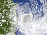
Cyclone Alfred spotted from space
Tropical Cyclone Alfred has been captured on NASA’s live camera on the International Space Station as it approaches the Queensland coast.
The cyclone can be seen orbiting about 400km from sea level.

Vital SES warning: Stay across rapidly evolving details as storm intensifies
NSW SES Deputy Commissioner Deb Platts says it is vital people stay up to date on the latest developments as Cyclone Alfred edges towards the coast.
She says warnings and alerts will continue to rapidly evolve throughout the storm.
‘We need people to keep up to date with the warnings.
‘We’ve seen that overnight where we’ve been able to change some evacuation warnings based on the Bureau of Meteorology’s information and forecasts.’
Her advice comes as heavy rainfall and gale force winds, with gusts of more than 100km/h, are already pummeling southeast Queensland and northern NSW with conditions to intensify throughout the day.
NSW premier disappointed residents are ignoring vital evacuation warnings
NSW Premier Chris Minns is in Grafton, where the residents of the Northern Rivers city are still hurting from the devastation of raging floods less than two years ago.
‘I wouldn’t wish this on my worst enemy – this is incredibly traumatic for a community who has gone through so much,’ Mr Minns told the local ABC radio station this morning.
‘We’ll get through this – but you have to listen to emergency broadcasts.’
However, he says he is disappointed some stubborn residents have failed to heed last night’s evacuation warnings and continue to put themselves in danger by refusing to leave their at-risk homes.
‘Even the best resourced emergency department in the world… is not going to (have) enough boats for enough houses in the event of a catastrophic natural disaster,’ he says.
Military ready to assist with state of emergency
The military is on standby to assist emergency services crews as authorities are flooded with pleas for help as thunderous storms settle across the coast.
Southeast Queensland’s 2,000 SES volunteers have been bolstered by 100 reinforcements from the state’s north.
Emergency Management Minister Jenny McAllister says the defence force is ready to assist as Cyclone Alfred unleashes its wrath on the Australian coast.
‘From a Commonwealth perspective, we have indicated that the Australian Defence Force are on standby and, of course, have agreed to Queensland’s request that we preposition aerial support for any search and rescue,’ she told the Today show this morning.
‘We’ve also got personnel available to do welfare checks after Cyclone Alfred makes landfall.
‘Very significant preparations are underway here.’
Beachcomber swept from shore in matter of seconds as monster waves strike Gold Coast
Astonishing footage has captured the moment a man using a metal detector is almost swept away in giant swell as Cyclone Alfred nears the coast.
The man was only given a few seconds notice before the monster wave swept him off his feet and slammed him into a sand bank.
The footage, believed to have been filmed at a beach on the Gold Coast, quickly caught the attention of Aussies after it was shared online.
Many voiced their frustrations at the ‘idiot’ act just hours before Cyclone Alfred was due to cross the Queensland coast on Saturday.
‘What a moron,’ one wrote.
‘Probably better to wait a bit,’ a second pointed out.
‘This is incredible for those people who don’t know Gold Coast beaches stay away, it’s only for a couple of days. The water is unpredictable,’ a third said.
Warning for reckless ‘idiots’: You could be fined up to $16,000 amid looming disaster
David Crisafulli is savaging the ‘handful of idiots’ who have created unnecessary headaches for emergency services by venturing into the swelling seas.
The Queensland Premier says that, in once instance, precious resources had to be wasted rescuing a jet-skier after they ignored warnings.
‘You have a handful of idiots who do that, and in the end, they don’t just put themselves at risk, they put the emergency services who may have to go and rescue them as well,’ he says.
It comes as beaches from the Sunshine Coast to Byron Bay remain officially closed with authorities imploring people to keep clear and stay safe.
Acting Gold Coast Chief Superintendent Peter Miles warns the city has issued a disaster declaration, giving police extra powers to enforce community safety and slap people with fines to up to $16,000 for ‘reckless actions’.
Queensland premier warns: Flee now or bunker down for the duration
Queensland Premier David Crisafulli is urging millions of residents across the state’s southeast to finalise their plans and either bunker down now or evacuate before Cyclone Alfred hits and it’s too late.
‘As the system continues to move in, my message to Queenslanders is… the best place to be is at home,’ he said.
‘If you are in a storm tide zone, or in an area where you know there is riverine flooding, you really need to consider and think about your evacuation now.’
Mr Crisafulli said the government will strive to keep bridges and roads open as long as possible to allow those fleeing to get out, and emergency services access in.
‘The potential for waves and wind, rainfall and then eventually flooding remains real,’ Mr Crisafulli said.
‘It is a strong system, and that delayed run into the coast does give people who may not have finished their preparations that little bit more of a window.
‘That prospect of a crossing late into Thursday, into Friday, well, that window has been pushed further into Friday, so that gives a little bit more time for those who may need a bit more time to get ready.’
He warned severe weather conditions will intensify throughout the day before the storm strikes overnight.
‘The bureau is telling us that increasingly we’ll start to feel those wind speeds even in the likes of Brisbane and the Sunshine Coast,’ he said.
‘And then there’s that rainfall issue as well — it’s a large system and the prospect of a lot rain over the next few days is a challenge.’
Where is Cyclone Alfred now?
Cyclone Alfred is now less than 200km out of Brisbane as wild storms and gale-force winds hammer the Queensland capital and its surrounds.
The category 2 system was about 190km east of the state capital and 180km northeast of the Gold Coast at 4am on Friday as it continues on its collision course with the coast.
The tropical cyclone is predicted to maintain its intensity until it makes landfall overnight Friday most likely close to Moreton Bay between Noosa and Coolangatta.
The storm is then expected to weaken slightly to a category 1 system as it makes its way inland.
Brisbane to be battered by fierce thunderstorms for hours – even before Cyclone Alfred strikes
Bureau of Meteorology senior forecaster Christine Johnson has warned Brisbane will experience fierce thunderstorm conditions for up to six hours – even before the force of Cyclone Alfred hits.
‘It’ll be those sort of conditions that we’re used to seeing for 20 minutes or so at a time with a thunderstorm coming through… but potentially sustained for six hours or more,’ she told ABC Radio Brisbane on Friday morning.
She added that Moreton Island is now at the epicentre of the superstorm’s path.
‘It looks like it will initially make landfall on Moreton Island in the very earlier hours of tomorrow morning, or close to midnight, and then move across the mainland coast through the early hours of tomorrow,’ she says.
‘We will feel the effects well and truly before it makes landfall.’
Cyclone’s delayed arrival could trigger five days of deadly floods
There are warnings Cyclone Alfred’s ‘erratic’, slow moving path could trigger five days of severe flooding across large stretches of southeast Queensland and northeast NSW.
The category 2 storm had initially been predicted to hit the coast overnight Thursday but its arrival has been delayed by more than 24 hours as it continues to change course.
The cyclone is now less than 200km from Brisbane and is expected to hit the coast late Friday night or in the early hours of Saturday morning.
The belated arrival means that the region is now expected to be battered by storms for up to five days instead of three, with wind gusts of up to 155km/h and a deluge of 800mm rain predicted over the weekend.
More than 20,000 home were already in darkness overnight amid widespread blackouts across the Gold Coast and Tweed Heads after the region was battered by storms.
Thousands of residents across northeast NSW were urged to evacuate on Thursday night or risk being cut off for days by floodwaters.
Supermarkets throughout the region have closed with Daily Mail Australia hearing reports people have been heading inland to stock up on supplies as far away as Warwick and Clifton.
Brace for impact: Tropical Cyclone Alfred changes its destructive course AGAIN
Cyclone Alfred has changed its course once again as it prepares to make imminent impact.
Four million residents in northern NSW and southeast Queensland will hunker down on Friday as gale force winds of 155km/h and torrential rainfall totals of up to 450mm smash the region.
The slow moving category-two system is now 245km east of Brisbane after Alfred spun back around to the east for a second time on Thursday.
Current modelling suggests that Alfred is expected to make landfall early Saturday morning near Redcliffe, 41km north of Brisbane, slightly further north than previously indicated.
Heavy overnight rainfalls could lead to dangerous and life-threatening flooding as Alfred approaches the coast.
‘Due to the very slow moving nature of the cyclone, there is a very high risk of significant impacts due to widespread heavy rainfall over the coming days,’ the latest Bureau of Meteorology alert states.
‘The centre of Alfred is expected to cross the coast Friday night or early Saturday morning.’
Gusts of up to 120km/h developed near the coasts between Cape Moreton and Cape Byron late Thursday which are expected to extend to coastal and island communities between Noosa and Ballina early Friday.
Rainfall amounts could reach between 200mm and 250mm over six hours and between 350mm and 450mm within a 24 hour period.
A dangerous storm tide is also likely for exposed coastal areas between Cape Moreton and Yamba, including the Gold Coast and Byron Bay beaches.
Hundreds of residents have already evacuated their homes to seek shelter higher ground.At least 20,000 homes across both regions are also without power.


At least 20,000 homes without power
More than 20,000 homes were in darkness as of midnight on Thursday, with more than 12,000 Energex customers in the Gold Coast affected.
Energex spokesperson Brett Judge urged customers to remain patient.
‘Where our crews can respond, they will, and where they can’t, they can’t get power on,’ he told ABC Radio.
Meanwhile, 10,000 homes and businesses between Tweed Heads and Bulahdelah lost power on Thursday afternoon, according to Essential Energy.
‘Crews are working to restore as soon as it is safe to do so as outages occur, with some locations unable to be accessed due to heavy rainfall flooding river crossings or water on the roads,’ a spokesperson said.
Aussies have been warned their homes may be without power for a long time due to the dangerous conditions forecast.
Island residents urged to ‘take shelter now’
Redland Council has issued an urgent warning for Moreton Bay and Stradbroke Island residents to take shelter inside their homes now.
Destructive and persistent winds from Tropical Cyclone Alfred will begin from 4am on Friday as Cyclone Alfred makes landfall.
‘You may need to go to the strongest, safest part of the building you are in. This will be away from big windows,’ the council advised.
‘It could be a bathroom, walk-in wardrobe or hallway. Stay there. This could take several hours.
‘Emergency services will not be able [to] get to you because it is too dangerous.
‘Winds could stop suddenly if the eye of the cyclone goes over. Very dangerous winds could start again quickly from a different direction.’
Power, phone and internet services ‘could be out for a long time’.
Residents have also been advised to cover windows in their ‘safe rooms’ with mattresses or heavy blankets in case the glass shatters and to shelter beneath mattresses and blankets incase the roof of their house blows off.
‘Listen to local radio on your battery-powered radio for updates; keep all doors and windows closed; stay in your safe place until you are told it is safe. This could take several hours,’ the council instructed.